Image coordinates play an important role in finding certain locations on maps. They consist of latitude and longitude values that enable the locating of any point on Earth. Whether you're a photographer, a tourist or just someone who loves going to new places, proper understanding of reading and usage of such coordinates can make your time worthwhile.
Your device often features GPS coordinates as tags of a photo that you have taken. What this means is that the image is more than just an attractive shot but also has its location marked precisely for purposes of finding one’s way or sharing it with others. Furthermore, knowledge of these coordinates could serve useful in several fields like geography, cartography and even real-estate.
How to Find Coordinates in Google Maps

It is easy to locate coordinates on Google Maps. You need to do these things:
- Open Google Maps on your device.
- Right-click on the location you want to find the coordinates for.
- Select "What's here?" from the menu that appears.
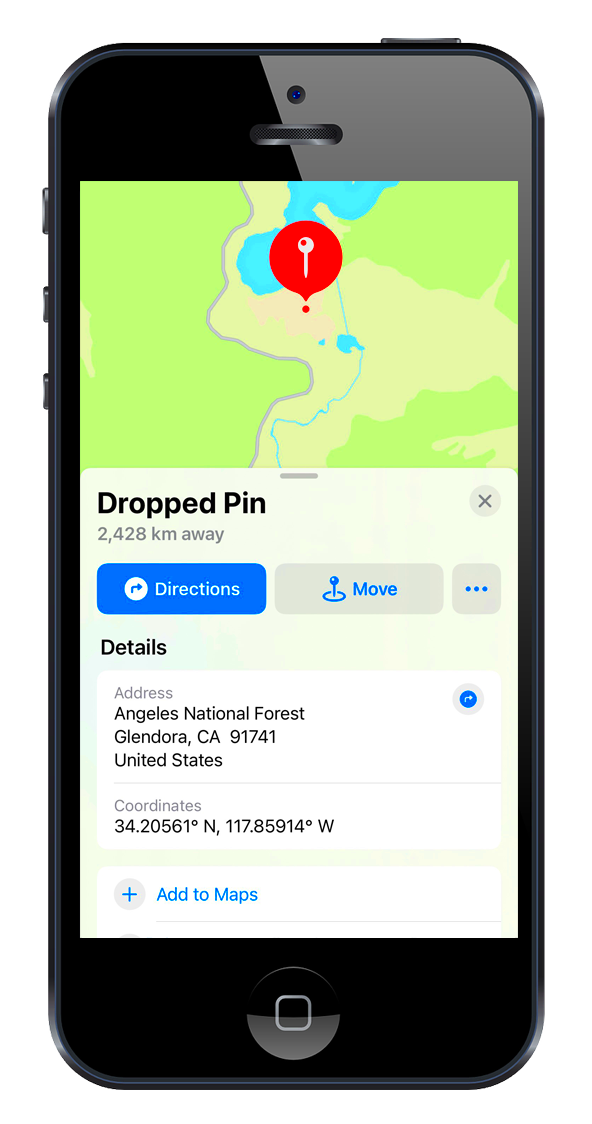
- A box at the bottom will display the latitude and longitude.
Using the search box, you can also locate coordinates. Simply type in a place name or an address and the map will reveal its position along with coordinates. That’s how simple it is!
Using GPS Apps for Image Location
In real time, GPS applications could be the best means for finding out where the pictures were taken. Some of the most common apps are:
- Google Maps: Not just for navigation, it also allows you to save locations and share them.
- Apple Maps: A great option for iPhone users, providing detailed directions and coordinates.
- Waze: Primarily a navigation app, but it offers location sharing features.
- Map My Run: Perfect for outdoor enthusiasts, this app tracks your location and can help you save coordinates for later.
Outdoor activities often rely on most GPS apps, which utilize satellite signals for precise coordinates. Including these coordinates in your images can help tell an interesting and detailed story about where you’ve been or what you’ve done while travelling.
Extracting Coordinates from Photos
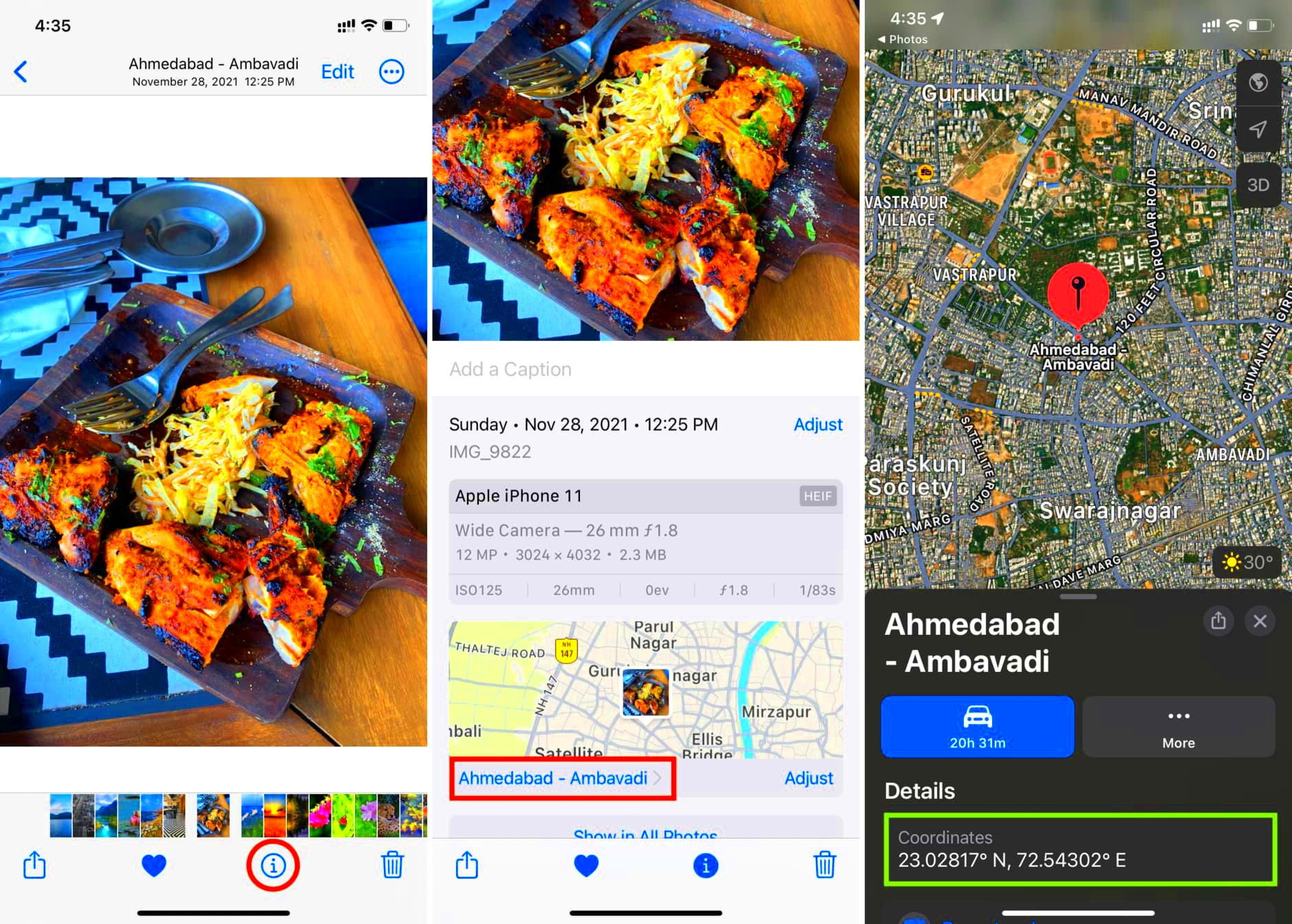
Have you ever thought about where was that picture taken? Nowadays, modern cameras and smartphones automatically embed latitude and longitude coordinates in photographs’ metadata called EXIF data. By extracting these coordinates, you can encounter similar situations again, arrange your images or even inform mates where you are located. This section will show how simple it is to extract these valuable coordinates from the photos.
The retrieval of coordinates may simply be achieved by following the procedures outlined below:
- Open the photo on your device.
- If you're using a Windows PC, right-click on the image and select "Properties." Go to the "Details" tab to find the GPS coordinates.
- For Mac users, right-click the image, select "Get Info," and look for GPS data under "More Info."
- Alternatively, you can use various online EXIF viewers or apps that allow you to upload your photo and view all embedded metadata.
This is how, by extracting these coordinates, you can find the perfect spot for your next photoshoot or pathway during your travels. This makes it look like having an individual travel journal embedded in such images!
Importance of Image Coordinates for Photography
In photography, image coordinates are significant, especially for those who are fond of documenting their trips. If you know the exact place a picture was captured, it would improve not only the narratives part of your work but also make it more appealing. Image coordinates are important for the following reasons:
- Organizing Photos: Coordinates help in categorizing images based on location, making it easier to find specific photos later.
- Adding Context: When sharing photos, coordinates provide viewers with context about the setting, enhancing their experience.
- Travel Planning: Coordinates can assist in planning future trips by allowing you to revisit places you enjoyed.
- Geotagging: Many social media platforms use location data to display images on maps, giving your photos more exposure.
When one understands, and applies image coordinates, a photographer will have an appealing portfolio that reaches the needs of their audience on another level.
Common Mistakes When Locating Coordinates
It might look easy to determine co-ordinates, but there are a number of pitfalls which people often meet. Knowing these mistakes can assist you in saving money and not wasting much of your spare time. Some of these problems include:
- Ignoring Metadata: Many users overlook the importance of EXIF data, assuming that their images are just simple files. Always check your images for embedded GPS data.
- Using Inaccurate Tools: Some online tools may not read EXIF data correctly. Make sure to use reputable software or apps to extract coordinates.
- Not Updating Settings: Ensure your camera or smartphone has GPS enabled when taking photos. If it's off, your images won't have location data.
- Confusing Latitude and Longitude: It’s easy to mix up these two values. Remember, latitude comes first, followed by longitude (e.g., 40.7128° N, 74.0060° W).
If we remain mindful of the typical blunders mentioned above, we will find ourselves more adept at handling image-space coordinates thereby ensuring that our photographic escapades run in an orderly manner!
Best Practices for Using Coordinates Effectively
Using coordinates efficiently might help you improve your navigation abilities and also manage your photos effectively. Regardless of whether you are a tourist, photographer, or simply interested in discovering new areas, there are numerous best approaches for using coordinates. Therefore let us analyze some advice that can make it easier and more fun for you.
These are few of the most prevalent guidelines that should be taken into account:
- Always Enable GPS: Before heading out, make sure your device’s GPS is turned on. This ensures that every photo you take will have accurate location data.
- Label Your Images: When uploading photos to your computer or cloud storage, include location details in the file names or descriptions for easy identification.
- Use Mapping Software: Utilize tools like Google Earth or dedicated mapping software to visualize your coordinates and create custom maps of your favorite locations.
- Keep Backup Records: Always save the coordinates separately, perhaps in a document or spreadsheet, especially if they are critical for your work.
- Share Wisely: If you’re sharing images online, consider privacy settings. Make sure you’re comfortable with others knowing your exact location.
When sticking to this excellent behavior, you make sure that your coordinates are maximized so that your pictures are better and the trips you take will always be remembered.
FAQ about Image Coordinates on Maps and Apps
While plunging into the universe of image coordinates, you could have several inquiries. Amidst some often posed queries, we provide answers to common worries and misunderstandings.
- What are image coordinates?
- Image coordinates are geographical data embedded in photos, typically consisting of latitude and longitude.
- How do I check if my photo has GPS data?
- You can check this by viewing the photo’s EXIF data through your device’s properties or using an online EXIF viewer.
- Can I edit the coordinates of my photos?
- Yes, there are various apps and software tools that allow you to edit EXIF data, including GPS coordinates.
- Are there privacy concerns with GPS data?
- Yes, sharing images with GPS data can reveal your location. Always be cautious when sharing online.
- Can I use coordinates without an internet connection?
- Yes, once you have the coordinates, you can use them in offline maps or navigation apps.
Conclusion on Finding Image Coordinates
The art of locating image coordinates is an invaluable expertise for enhancing photography skills, travel experiences and storytelling. Remembering times spent together through photographs, sharing of adventures with others and generically organizing pictures are some of things that can be done by knowing how to extract and use coordinates. Recently it has become easier than ever to access this information due to the advent of smartphones as well as digital cameras
There is need for you to make sure that your device’s settings have been checked to see if the GPS has been enabled; and use the tools and applications that are meant for it. Best practices and being mindful of what you shouldn’t do create an avenue in which using image coordinates can greatly contribute to your travels.
Hence, the next time you capture an image reflect on what transpired at that place long ago. Using locational data, we will offer detailed insight into our past and take it out for everyone else to see!

 admin
admin


